Tempest
Investigation of deep water GOM subsalt imaging
Performing depth imaging is an essential part of deep water GOM exploration. Over the years, depth imaging technology has provided reliable seismic images below complicated salt bodies and has been implemented in workflows for prospect generation. However, we normally don't investigate the accuracy of depth migrated volumes. In order to learn about the accuracy of deep water GOM model building and depth imaging, we created a 3D VTI anisotropic earth model and 3D seismic dataset representing true subsalt GOM geology. The anisotropic model, dataset and RTM PSDM are called the Tempest dataset.
Historical Background
The Tempest Project was initiated a few years ago by Devon Energy in an effort to analyze the accuracy of depth imaging technology applied in deep water GOM. The project was executed in three phases. The first phase included design and construction of a realistic deep water GOM geological model, and simulation and imaging of the dataset using the known velocity model. Phase two was to provide the simulated data to several processing companies who regularly process data for Devon Energy and have them construct a model and apply prestack depth migration as if the data were real GOM field data. The third phase included interpretation and analysis of the depth imaged volumes to (1) compare the derived prestack depth migration results to results achieved using the exact earth model, (2) compare the developed velocity models to the exact velocity model, and (3) compare the synthetic imaged data to field acquired data. A summary of the project was published at the 2009 Leading Edge article: The Tempest project – Addressing Challenges in Deep water Gulf of Mexico depth imaging through geologic models and numerical simulation (Seitchik et. al., 2009, TLE, pp. 546-553). The fourth phase of the Tempest project was to upgrade the initial model to a VTI anisotropic model, simulate using a VTI modeling program and to apply VTI Reverse Time Migration. This was published at the 2011 Geophysics publication: Investigation Of deep-water Gulf of Mexico subsalt imaging using anisotropic model, Dataset and RTM – Tempest (Hoxha et. al., Geophysics, Vol. 76. No.5) The anisotropic Tempest model, dataset and PSDM volume are now being licensed to the industry by Devon Energy.
New Developments
Several new data acquisition, processing and depth imaging technologies were introduced to the industry in the past few years. These include (a) use of WAZ data, (b) use of RTM as the leading tool for PSDM, (c) a move from isotropic model building and depth imaging to anisotropic model building and depth imaging, and (d) development and use of more sophisticated demultiple techniques, mainly for removal of surface related multiples. Leveraging lessons learned from the isotropic Tempest model and dataset, the model and simulated seismic dataset were upgraded so that it can be used in the testing, evaluation and assessment of these new technologies.
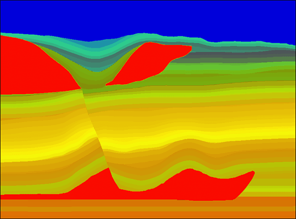
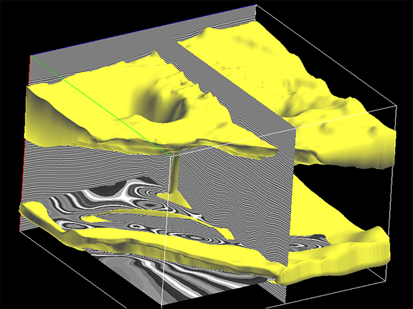
The upgraded Tempest model is a fully VTI anisotropic model. This model was constructed using actual well data and is a calibrated representation of the deep water GOM exploration setting involving complex salt bodies and clastic stratigraphy. The Tempest anisotropic model was constructed using velocity and anisotropic functions, derived from field data. It is a unique representation of true deep water GOM geological model consisting of well derived velocity field and well derived anisotropic field. By having a synthetic anisotropic seismic data and a known velocity model, we can quantitatively measure the accuracy of the anisotropic model building and depth imaging techniques that are routinely used with real field data as well as new depth imaging workflows applied for subsalt exploration.
Data Simulation
VTI anisotropic acoustic wavefield simulation was used to create the VTI anisotropic dataset. The resulting dataset can therefore be used for investigation of anisotropic velocity analysis and model building. In order to use the dataset for investigation of WAZ acquisition design, each shot was recorded over a large recording area. Subsets of the datasets can be extracted and processed, resulting with imaged volumes that correspond to various acquisition designs. The Tempest dataset was recorded using a free surface boundary condition. The dataset consists of both surface multiples as well as inner bed multiples, and is suitable for testing of multiple elimination techniques.
Depth Imaging
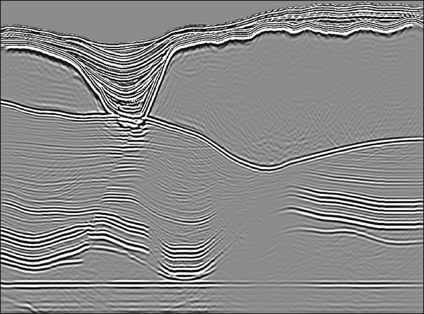
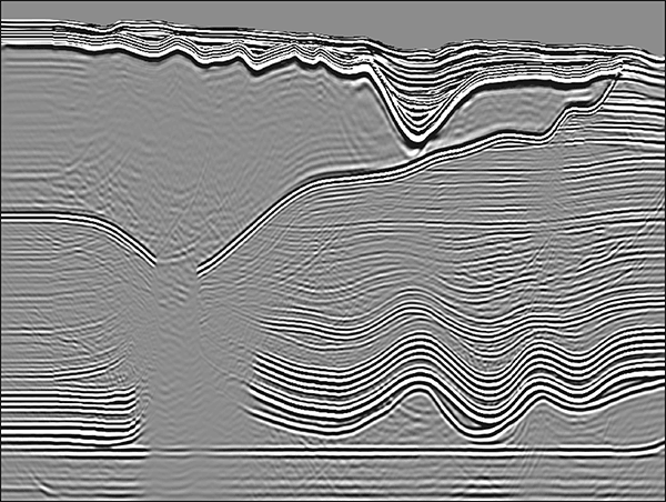
The main tool used for the depth imaging of the anisotropic Tempest dataset is a VTI anisotropic common shot RTM algorithm. During the past few years, anisotropic RTM PSDM has become the leading depth imaging algorithm used for imaging of GOM data. The Tempest dataset and RTM PSDM volume provide a data set that can be used for studying the advantages and character of Reverse Time Migration Prestack depth migration.
The main tool used for the depth imaging of the anisotropic Tempest dataset is a VTI anisotropic common shot RTM algorithm. The RTM PSDM was done using the natural grid of the dataset and using a 0Hz – 25Hz frequency range. During the past few years, anisotropic RTM PSDM has become the leading depth imaging algorithm used for imaging of GOM data. The Tempest RTM PSDM volume is an integral part of the Tempest project and provides a data set that can be used for studying the advantages and character of Reverse Time Migration Prestack depth migration.
Data License
The Tempest model and dataset are the results of several years of development of deep water GOM geological model, synthetic dataset and PSDM. The current model and dataset include a VTI geological model (i.e. vertical velocity, delta and epsilon volumes), a synthetic dataset consisting of 20,075 shots simulated using a VTI high order FD code, and a VTI PSDM RTM volume that was generated using our proprietary RTM code.
There are numerous technologies that can that can be tested and verified using the Tempest dataset. These include multiple elimination techniques, testing of proprietary RTM algorithms, and the testing of the accuracy of anisotropic velocity analysis techniques used in processing of WAZ data. The Tempest dataset size is about 6TB and includes all the header information is needed to be directly input to any PSDM process. The simulated dataset is stored as WAZ shots, written in standard SEGY format and can be processed as dataset acquired in the field.
The project was done in collaboration between Devon Energy and SeismicCity. A license to the model and dataset can be purchased from Devon Energy. For details about purchasing a Tempest data license please contact SeismicCity. The license includes the model, simulated dataset and RTM PSDM volume. The data license comes with full publication rights.
Acknowledgments
The original Tempest data was provided courtesy of Devon Energy Corporation.


